At Xradar, we are redefining the standard for Concrete Corrosion Mapping with expert interpretation of data from various complementary methods. In contrast, elsewhere within the industry, there is a reliance on methods that do not provide the level of certainty of Xradar, leaving critical risks potentially undetected.
What is corrosion and why does it occur?
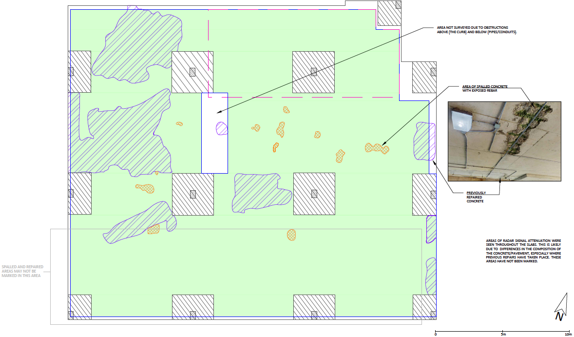
With corrosion it’s not what’s visible that is the concern.
Concrete itself doesn’t corrode, but the reinforcing steel (rebar) embedded inside it does. Over time, chloride ingress (from road salts, de-icing agents, or marine exposure) and carbonation (the reaction of CO₂ with the concrete) break down the natural alkaline environment that protects steel from rusting. Once that protective layer is compromised, steel begins to corrode and expand.
When steel corrodes, rust occupies up to 6–7 times more volume than the original steel. This expansion creates internal pressure within the concrete, and cracking and spalling will eventually occur.
The pressure causes the concrete cover to crack and eventually spall (break off), exposing more rebar, accelerating the corrosion cycle further.
As rebar cross-sections reduce due to corrosion, the structural capacity of the element declines, which can compromise load-bearing capacity, stiffness, and overall durability.
At this stage, unfortunately, the problems then only escalate further. Cracks allow water, oxygen, and salts to penetrate more easily, further accelerating corrosion and reducing service life. Left unchecked, corrosion leads to unsafe structures, costly repairs, and in severe cases, structural failure. A very famous case of this was the collapse of the de la Concorde overpass in September 2006, killing five people underneath and injuring six others who were on the overpass.
For owners and managers of those structures, it means higher maintenance costs, shorter asset lifespans, and liability risks. So, the question to ask is; How can you find/map and repair corrosion before it’s too late?
Why does corrosion mapping matter?
By detecting and mapping corrosion proactively, you can prevent future challenges. The benefits are clear:
- Engineers can pinpoint areas of concern before major deterioration occurs.
- You can plan targeted, cost-effective repairs rather than expensive, large-scale replacements.
- Structures maintain their safety, longevity, and reliability.
Corrosion is the hidden enemy of reinforced concrete – weakening steel, cracking concrete, and threatening structural safety. Mapping it early gives owners and engineers the insight to protect their assets before it’s too late.
Without Xradar, how would you map corrosion?
There are many methods of mapping corrosion, but all come with limitations. Used in isolation, none provides a complete or highly reliable solution. Here are some of the most common approaches:
Half cell potential
A long-established electrochemical test that measures voltage differences on the concrete surface to indicate areas where reinforcing steel is likely to corrode.
While useful for spotting probable corrosion zones, results can be misleading if not paired with other methods, as the test only shows the probability of corrosion, often divided into a <10% chance, more than 90% chance, and the in-between is classed as “unknown”.
GPR Amplitude Mapping (Computer-Assisted Visual Interpretation)
Early systems such as IRIS (Integrated Radar Inspection System) and HERMES (High-Speed Electromagnetic Roadway Measurement and Evaluation System) in the 1990s showed potential for mapping deterioration.
However, these methods have questionable accuracy. Their numerical analysis often cannot distinguish between surface defects, moisture, or actual corroded rebar, leading to false readings where water and salt may exist for example.
These limitations make them unreliable as standalone tools for corrosion assessment.

Chain Drag
A very simple, low-tech method where a chain is dragged across the surface of a concrete slab to detect hollow or delaminated areas by sound.
While cheap and fast, it is highly subjective, depending entirely on the operator’s ear and interpretation.
It only identifies advanced stages of deterioration, missing early-stage corrosion entirely.
Sounding (Hammer Tap or Impact Echo)
Similar to chain drag, this involves striking the surface and listening for hollow sounds that indicate voids or delamination, which is a result of corrosion.
Sounding is effective for confirming obvious deterioration but too crude for precise mapping or early detection. Results can be very subjective, and as a result, can vary significantly depending on the operator and site conditions.
Advanced technology such as XRSounder adds some objectivity to this method, primarily targeting delamination, whilst still benefiting from complementary methods outlined below.
Conventional GPR
Handheld scanners like the Hilti PS 1000 are common tools for contractors, primarily used for locating rebar and conduits before cutting or drilling.
While effective for small-scale safety checks, these devices were never designed for corrosion mapping.
Conventional GPR does not detect corrosion directly or obviously. It requires expert interpretation across multiple datasets, something many providers may lack.
The simple on-screen visualizations are not sufficient for long-term asset management, as they don’t produce the comprehensive reports needed for decision-making.
While adequate for basic rebar location, and in advanced cases the increased conductivity in concrete surrounding corroded steel, these devices often fall short in corrosion mapping applications.
Each of these methods can offer some insight, but they all come with trade-offs. Accuracy is limited, results are often dependent on technician interpretation, and none provide the integrated, reliable, and actionable insight required for confident repair and asset management decisions.
Where Xradar has an advantage over more common methods of corrosion mapping
Xradar combines the most advanced technology available, integrating multiple methods, highly trained technicians, and actionable reporting. This delivers results that are unmatched in accuracy, speed, and reliability.
- Integrated Methods for Maximum Accuracy
- Most providers rely on a single method, which can lead to false positives/negatives.
- Xradar applies a multi-tool approach, combining Ground Penetrating Radar (GPR), Half-Cell Potential Mapping, and the proprietary XRSounder when required. This gives the clearest and most reliable total picture of corrosion activity.
- Unmatched Technician Training & Expertise
- Xradar technicians are trained through the Xradar Academy, an extremely comprehensive training program, enabling technicians to confidently identify corroded rebar, its location, spacing, and depth.
- This expertise means clients get practical insights that directly support repair and maintenance decisions.
- Comprehensive, Actionable Reporting
- Standard reports from competitors can be technical, fragmented, or hard to act on.
- Xradar reporting integrates visual inspections, 3D laser scanning, and corrosion mapping data into clear, visually intuitive deliverables.
- Clients don’t just receive data – they get easy-to-understand, actionable insights that support immediate next steps.
The result is corrosion mapping you can rely on for informed decision-making, cost-effective maintenance, and safer construction practices.


Why It Matters
Across Canada and globally, construction and infrastructure projects face mounting pressure to maintain public safety, extend the lifespan of assets, and control maintenance budgets. Corrosion is one of the most significant threats to reinforced concrete, often hidden until the damage is advanced. Detecting and understanding it early and proactively is critical.
Where other methods may fall short, Xradar™ delivers:
- More accurate data for long-term asset management – giving engineers and owners the confidence to plan repairs based on facts, not assumptions.
- Reduced risk of missed corrosion or hidden deterioration – minimizing surprises that can escalate into emergency shutdowns or structural failures.
- Faster, safer, and more comprehensive scanning – reducing downtime on active sites such as bridges, roads, and dams, and providing actionable results quickly.
The importance of this work goes beyond just inspection. By investing in comprehensive corrosion mapping today, building owners, engineers, and contractors can:
- Prevent costly failures before they occur.
- Optimize repair budgets, targeting only the areas that need intervention.
- Safeguard communities by ensuring the ongoing safety of bridges, buildings, and public infrastructure.
- Protect investments by extending the service life of concrete assets.